Interference with satellite navigation is neither an emerging threat nor a run of isolated incidents.
In July 2026 the European Union Aviation Safety Agency issued the fourth revision of its safety bulletin on the problem, describing incidents as more severe, more sophisticated and more disruptive than before. EUROCONTROL estimates that up to 38% of European en-route traffic now operates through regions that are regularly affected. IATA has recorded a 220% rise in satellite navigation signal-loss events between 2021 and 2024, and a further 193% increase in 2025 against 2023.
These are no longer dots on an interference map. They are large, persistent zones through which hundreds of commercial aircraft pass every day.
A single spoofing event can disturb more than a dozen aircraft systems at once, flight management, inertial navigation, terrain and collision warning, position reporting to air traffic control, data-link messaging, even the cockpit clock. Contamination can persist for hours after the aircraft has left the affected area. Yet the industry’s response remains mainly reactive.
Current tools map only the affected routes, report on incidents and give operational guidance. That means they stop at the incident itself, not fulfilling the highest priority of the industry: geolocating the spoofing and jamming equipment to prevent future incidents.
Moving from symptom mapping to tracking intelligence
To bridge this urgent and critical gap, Spire has launched the beta version of the GNSS spoofing intelligence platform, that goes beyond symptom mapping to identify and locate the interference sources themselves.
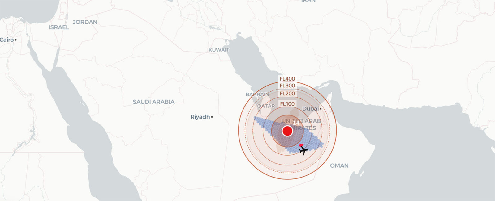
Spire combines aviation analytics with satellite Radio Frequency Geolocation (RFGL) to detect, pinpoint, and profile interference equipment, using the position data aircraft already broadcast. Aircraft observations identify the area a transmitter is operating in; Spire’s geolocation satellites are then tasked to that area to confirm the position. A planned future phase will add continuous monitoring to alert on new equipment and track shifts in operational patterns.
When treating the analysis of the actual interference equipment as the source for the tracking intelligence, it changes the kind of intelligence needed:
- Equipment-centric: Tracks the jamming/spoofing equipment itself as a permanent source.
- Pattern-recognition: Identifies deliberate operating schedules by identifying exact daily patterns.
- Location-mapping: Uses aircraft displacement data to calculate the geographic area the equipment is operating in.
- Long-term continuity: Monitors the source over weeks and months to catch movement, schedule shifts, or dormancy.
- Reach estimation: Estimates how far each transmitter’s influence extends, so operators can see whether it touches the airspace and routes they care about.
Shifting the analysis: How Spire’s GNSS spoofing intelligence platform works
The platform fundamentally changes the unit of analysis for aviation safety and defence intelligence. Instead of recording individual flight anomalies, Spire is using global ADS-B data across conflict zones and high-trafficked airspaces to develop detailed profiles of the spoofing equipment itself.
This transition from analysing affected flights to analysing the source/ itself, powered by three core technical capabilities:
- Detect spoofing: Identifies false GPS signals by flagging sudden position jumps (often 40–90 km) that violate basic flight physics, like movements inconsistent with the aircraft’s speed, heading, and altitude trajectory. Jamming is detected separately, by watching navigation quality indicators degrade across several aircraft in the same area. Spoofing leaves those indicators looking normal, which is exactly why it needs a different method
- Estimate true location: Reconstructs where the aircraft actually was by interpolating its trajectory between the last known valid position before the spoofing incident and the first valid position after.
- Locate the equipment location: Combines displacement vectors (real vs. spoofed positions) from multiple affected aircraft into a probability-weighted heat map that converges on the ground area the signals come from, narrowing to tens of square kilometres where observations are dense. Spire’s radio frequency geolocation satellites can then be tasked to that area to confirm the position to within 70–600 m.
Delivering actionable intelligence across organisations
The GNSS spoofing intelligence platform delivers daily and weekly intelligence reports in a format designed to move inside security-conscious organizations:
- Daily Report: Captures a 24-hour window, opening with four headline figures and followed by six sections: the KPI summary, an hourly activity heatmap, the active equipment register, critical activity windows, airspace (FIR) exposure, and written regional assessments.
- Weekly Summary Report: Covers Monday–Sunday to track long-term trends. It resolves unique aircraft counts, establishes weekly operating schedules, tracks trend lines, flags new and dormant emitters, and includes a 7×24 hourly activity profile.
Both reports are delivered as a single self-contained web page, nothing to install, no login requirement, and printable to PDF for internal distribution and for secure environments with no network access.
The GNSS spoofing intelligence platform, directly serves two distinct sets of use cases:
1. Defence and intelligence operations
- Daily Electronic Warfare Situation Briefs: provides operational commanders with a clear morning summary of active emitters, newly detected equipment and pattern changes.
- Emitter Monitoring: Tracks relocation, schedule shifts, and dormancy over weeks building a standing assessment.
- Attribution Evidence: Generates displacement coordinates, location estimates, and operating schedules to support threat attribution assessments and faster decision-making.
2. Aviation safety and flight operations
- Pre-Flight Risk Mapping: Gives visibility into which airspace (FIR) regions have active transmitters versus clean corridors prior to flight dispatch.
- Tailored Procedure Guidance: Distinguishes between jamming and spoofing, so teams apply the right procedure for the interference type they are facing.
- Regulatory and Safety Compliance: Delivers a structured, evidence-based record of interference activity that supports reporting obligations to national and international authorities.
A new era for aviation safety and defense intelligence
As airspace traffic grows alongside regional geopolitical tensions, relying on spoofing and jamming post-incident mapping is no longer sufficient. Aviation safety requires knowing where interference originates before an aircraft enters impacted airspace.
By combining global ADB-S data with precise geolocation capabilities, Spire’s GNSS spoofing intelligence platform gives defence leaders and aviation authorities the emitter visibility needed to make global airspace a safer place.
Spire Aviation team has launched the beta version of the platform, and we are working with a small number of organisations to shape what it becomes.